DRIVING TO THE DAINTREE
The Cook Highway north of Cairns offers beautiful scenery ranging from secluded palm fringed tropical beaches, hidden coves and rugged headlands to the rich green of lush sugar-cane fields and rainforest covered mountains. This spectacular one and a half hour drive to Daintree Village takes you through the coastal villages of Ellis Beach and Wangetti to Rex Lookout, for a sweeping view south along the coast to Cairns that simply must be photographed.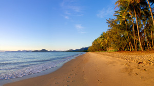
It is around a thirty-minute drive north of Port Douglas to Mossman, a pleasant little town set amongst the lush cane fields. Mossman Gorge is a must stop for all trips heading up to the Daintree and Cape Tribulation. The highway leaves the coast at Wonga Beach for a 15-kilometre drive through the forests of the Dagmar Ranges, and then into Daintree Village.
Public transport is limited throughout the Daintree region, so visitors not having their own transport should consider hiring a vehicle from one of the many car-hire companies in Cairns or Port Douglas.
The Daintree Ferry provides access into the Cape Tribulation area. This is accessible by conventional vehicles except during periods of heavy rain. The road is sealed as far as Cape Tribulation. Crossing the Daintree River via a vehicular ferry is an experience not to be missed. This ferry operates from 6am to midnight each day.
After crossing the Daintree Ferry you travel through lowland and tropical rainforest passing road junctions for Cape Kimberley and Cow Bay.
There are some excellent coastal views and several tourist attractions. The road runs over several high capes and alongside attractive beaches. Camping spots and accommodation are available. A small general store is located at Cow Bay. Limited fuel access is available.
Vehicle users can be assured that a 4WD is not required to drive through the Daintree Rainforest, however the Bloomfield Track which begins at the northern side of the rainforest, is suitable only for 4WDs.
The Bloomfield Track links Cape Tribulation and The Bloomfield River. It is a true 4WD Track as there is very little gravel on parts of the surface, unimproved creek crossings, steep climbs and decents, lots of mud and plenty of opportunity to get stuck if it is wet. The actual condition of the road varies enormously, and it can be anything from an easy drive, to almost or completely impassable.
Precautions
Please drive safely and carefully while in the area. If you wish to stop, pull over and park safely, not on the road. Sometimes it is safer to walk back to the attraction.
It is safe to drive at night, providing you obey the speed limits and keep a sharp lookout for wildlife. Wildlife is usually only killed by speeding drivers. Please respect private property while in the area.
During heavy rain, water does run over the road. Please be careful and check the depth before crossing. The water usually recedes quite quickly once the rain has stopped.
SELF DRIVE ITINERARY
This self drive itinerary offers a handy guideline to base your day of exploring Cape Tribulation and the Daintree Rainforest.
Depart Cairns 7:30am and Port Douglas at 8:30am approx.
Mossman Gorge 9:00am approx
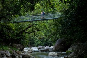
From Cairns, travel north for 80km along the Cook Highway to Mossman. In the centre of Mossman turn left into Johnston Road. This 5km bitumen road leads directly to the Mossman Gorge car park. Crystal clear water cascades over large granite boulders in the Mossman River gorge. There are two circuit tracks. A short, 400m track provides access to lookouts over the Mossman River. Beyond this is a 2.7km loop track through the rainforest.
Daintree River Cruise 10:00am approx
There are many river tours operating frequently throughout the day, some offering a short crocodile and wildlife spotting experiences while other interpretive cruises cater for special interest groups such as birdwatchers, naturalists and photographers. Bookings not required.
Daintree Discovery Centre 11:00am approx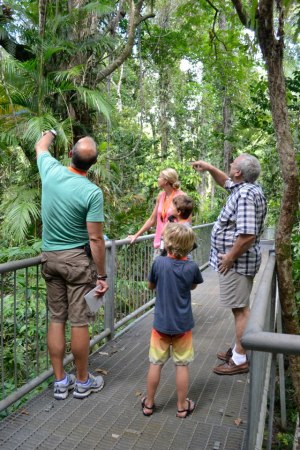
The Daintree Discovery Centre is an award-winning world class interpretive facility that allows visitors easy access to this unique rainforest wilderness via boardwalk tours, a 23 metre high Canopy Tower, Aerial Walkway and comprehensive Display Centre. The Discovery Centre offers visitors an opportunity to learn about and explore one of the few remaining unspoiled pockets of lowland rainforest in Far North Queensland.
Lunch at Cape Tribulation 1:00pm approx
Whet is a popular cafe for lunch in Cape Tribulation. This cafe and bar is a great venue for the busy explorer, a lunchtime salad and sandwich buffet is on offer, as well as a lunch and snack menu for those with a little more time to relax.
Cape Tribulation Beach 2:30pm approx
This is the showcase beach of the area. Protected by the Cape Tribulation headland, the water here is almost always calm and crystal clear. Take the boardwalk up the headland to the view point that provides magnificent views of where the Rainforest meets the Reef.
Marrdja Botanical Walk at Oliver Creek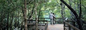
This interactive boardwalk has informative signage describing the unique plantlife including 'wait a while' spiky lawyer canes, cannonball mangrove and a superb fan-palm forest. This 1 km walk is easy and runs through a pocket of rainforest and mangroves. the walk is managed by the National Parks service and is very well managed.
Daintree Icecream Company 4:00pm approx
Don't miss stopping at The Icecream Company on your journey home, it is a must for any daytrip to Cape Tribulation! All the ice creams are made on the premises from tropical fruits grown in the company’s own orchards such as Black Sapote, Soursop, Wattle Seed and Jackfruit. The ice cream is primarily sold as a fixed sample pack - four flavours in a rather large cup for $5. Pretty good value, really!
Return to Port Douglas 5:30pm and Cairns at 6:30pm approx
CAIRNS TO PORT DOUGLAS
The Captain Cook Highway is Cairns’ coastal corridor; and one of the most spectacular ocean drives in Australia.
This scenic ribbon road winds its way along beautiful unspoiled coastline that is set against a spectacular backdrop of lush rainforest mountains.
Port Douglas is located 66km north of Cairns, just an hour’s drive.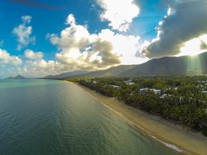
The beaches of Cairns stretch some 26 kilometres along the coastline and are known at the Northern Beaches. Consisting of eight separate communities: Machans Beach, Holloways Beach, Yorkeys Knob, Trinity Beach, Kewarra Beach, Clifton Beach, Palm Cove and Ellis Beach; each of these has its own distinctive character and flavour.
After 30-40 minutes you will pass through Wangetti and reach Rex Lookout, one of the most spectacular sights on the highway. Not only can you enjoy wonderful views over the ocean, but the area is very popular for hang gliding and other aerial sports. It’s a great spot to relax and watch them soaring on coastal thermals.
Just 5 minutes further is Turtle Cove and past here is Oak Beach a quiet, natural and unspoilt 2 kilometre beach.
Thala Beach Lodge is located on the northernmost headland of a 2km stretch of untouched coastline, and Port Douglas is just 10minutes further.
Port Douglas is nestled at the end of a peninsula, the tranquil waters of a natural harbour on one side of the village embrace a lively marina. Along the other side of the peninsula stretches the breathtaking sandy sweep of beautiful Four Mile Beach.
PORT DOUGLAS TO MOSSMAN
Port Douglas spolis the traveller with 5-star to budget accommodation, art galleries, markets and award-winning dining experiences second to none.
The Port Douglas Sunday Markets are a popular haunt for tourists and locals alike. Here you'll find original arts and crafts, jewellery, pottery, tropical clothing, fruit and vegetables, glassware, books, homemade foods, unique Australian goods, souvenirs and more.
The markets are also a chance to meet the locals, including the artists, street theatre performers and buskers.
Flagstaff Hill is the best place to capture the striking views of the town and its superb Four Mile Beach.
The Rainforest Habitat at the turn off to Port Douglas showcases more than 180 species of wildlife and offers Breakfast with the Birds or Lunch with the Lorikeets Experience. A great way to view the birdlife up close a personal. The Raindforest Habitat is an ideal stop off on your journey to the Daintree.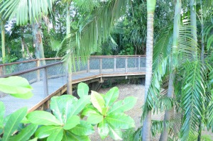
The journey to Mossman takes you through green canefields with rainforest clad mountains as the backdrop.
Mossman, is a picturesque little township nestled at the foot of the mountains.
The region's sugar capital the Mossman Central Mill throbs and hums its way through the sugar cane crushing season (June – October). Explore the country stores and historic pubs along the wide tree-lined main street.
Five minutes west of Mossman you will discover Mossman Gorge, a very accessible and scenic section of the World Heritage listed Daintree National Park.
Mossman is located 75 km from Cairns and 20 km from Port Douglas.
MOSSMAN TO DAINTREE VILLAGE
Journey through an ever-changing tropical landscape, a patchwork of white sandy palm-fringed beaches, waving cane-fields and jungle clad misty mountains.
See lush rural farmlands bordered by World Heritage listed rainforest and the majestic Daintree River. Heading north from the little sugar town of Mossman the road sweeps through sugar cane farmlands and, next to the picturesque Mossman Golf Club, is the turnoff to beautiful peaceful Newell Beach with it’s pristine sands and Coral Sea views.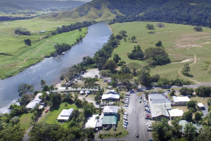
Further on is the turnoff to beautiful Whyanbeel Valley, home of Diane Cilento’s famous open-air playhouse. Diane puts on a number of world-class productions every year.
From Rocky Point a vista opens up of the northern rainforested ranges towards Cape Tribulation. Shortly you pass through rich beef-cattle pastures and soon reach the turnoff to idyllic Wonga Beach, miles of unspoilt sands with no major development - just a tropical beachfront caravan park.
Next in view are a commercial fish farm, beach horse rides, wildlife sanctuary and tropical gardens, then the turnoff to the Daintree ferry and Cape Tribulation. But to reach tiny historic Daintree Village drive straight ahead – here the road winds through the rainforest and soon you catch your first glimpse of the awesome Daintree River, with it’s prehistoric inhabitants the salt-water crocodiles.
The final stretch into Daintree Village winds through undulating farmland and luxuriant tropical vegetation with a beautiful mountain backdrop. Daintree was originally a settlement for timber-cutters and, until the road was completed in 1933, only accessible by river.
Today tourism and farming are the main industries and the region hosts every type of accommodation option from budget to 5-star resorts, B&B’s and hideaways, wildlife-spotting river cruises, artists’galleries, interpretive walks and restaurants.
THE DAINTREE RIVER FERRY
The Daintree Ferry provides access into the Cape Tribulation area. This is accessible by conventional vehicles except during periods of heavy rain. The road is sealed as far as Cape Tribulation. Crossing the Daintree River via a vehicular ferry is an experience not to be missed.
EFTPOS is available at the ferry between 8.30am-5pm seven days a week. At all other times users of the ferry need to pay cash unless they have a concessional card. 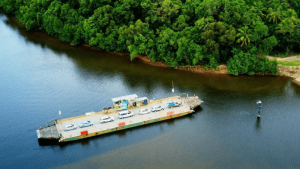
Daintree Ferry operates between 7.30am to 10am and 2.30pm to 5pm on Christmas Day.
After crossing the Daintree Ferry you travel through lowland and tropical rainforest passing road junctions for Cape Kimberley and Cow Bay.
The Daintree River Ferry operates from 6am to midnight each day.
For any enquiries please contact Customer Service on (07) 4099 9444.
DAINTREE RIVER TO CAPE TRIBULATION
Cross the Daintree River by ferry and travel north into the best of the Daintree - the Reef and Rainforest Coast.
Allow a minimum of one and a half hours drive time from Cairns to reach the ferry, one hour from Port Douglas.
Turn right at the signpost for Cape Tribulation and the Daintree Ferry. On the left just after the turn-off there is a series of lakes and billabongs which is old path of the Daintree River prior to the 1911 cyclone. Drive slowly as this is an excellent opportunity to spot birdlife in the billabong.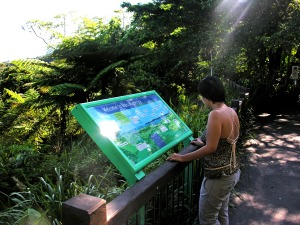
Looking northwards across the Daintree you can see the rainforested slopes of Thornton Peak. This mountain dominates the skyline and you will see it from several different angles on your journey. Very often there are clouds resting on top.
Check out the model of the Cassowary and the chicks, so that you know what they look like. You must remain in your vehicle while you are travelling on the ferry.
When you come off the ferry, pull over to the left and let the local traffic pass. You will have a more relaxing journey if you let the traffic get away. You may also be able to buy some cheap locally grown fruit from the banana stall which is often on the north side of the river.
A large part of the lowlands you will be travelling though is privately own freehold land. There are about 1000 rateable blocks, the majority between 1-2 hectares. The number of permanent residents is between 600-900 people. Many of these blocks have not been settled, and the rainforest is still intact.
The drive over the Alexander range is a stunning scenic rainforest drive and one of the most spectacular in the world - it has a sympathetic conservation design and its meandering nature enhances the ecotourism experience.
As you descend from the look-out there are several glimpses of views of the Daintree coastline.
The Cow Bay area has been classified as Outstanding Cassowary Habitat Zone by Corme and Moore (1993). In the lowlands and swamps of western Cow Bay the population density is as high as the best habitats in Mission Beach.
All the roads seen from the main road are cul-de-sacs servicing freehold blocks of land.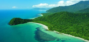
In the wet season Cooper Creek can be a barrier to cars, as the causeway may flood in heavy rain. In a small car do not try and cross the causeway until the depth of the water on the causeway drops to 0.2 metres. You need to have lots of patience as it is possible to be held up here for several hours if there are heavy rains in the area.
Noahs Range is the last range before you reach the Cape Tribulation area. Great view of Cape Tribulation and the fringing reef as you descend from Noahs Range into the Cape Trib valley.
Cape Tribulation Beach has toilets and picnic tables. You can walk to the look-out which takes 10 minutes. From here view the rainforest clad mountains which literally meets with the fringing reef. Remember to bring your camera as the view is spectacular! Just north of the Cape Trib Beach House is still some live coral on the edge of the fringing reef, if you have brought your snorkel.